
Days 46-65, Miles 702-903: A Crash Course in Mountaineering
- Jun 23, 2017
- 16 min read

The Pacific Crest Trail no longer exists. Its curves, switchbacks and climbs are all gone, buried under tons and tons of snow. We're entering the Sierra Nevada mountains after one of the highest snow years on record, and the hike has become a grueling mix of mountaineering and orienteering.
What's it like to hike the Sierras this year? Let's start with gear. You've got to carry a mandatory bear-proof canister, an unwieldy, heavy contraption. Mine's too large to fit in my pack, so I have to strap it to the top. Next you need crampons and an ice axe, tools that add more weight but will definitely save your life.
If your pack wasn't heavy enough, now double your food weight. These isolated mountains offer few resupply points, so it's necessary to carry food for many more days. Plus, slushing through snow is a massive calorie burner, so you've got to up your daily rations significantly to compensate for that. OK, now you're ready to hike. Once you get above 9,000 feet, massive snowbanks will start sprawling across the path like beached whales. Climb over them. By 10,000 feet, the trail will be gone. Luckily someone ahead of you made some decent tracks in the snow. Follow them. Wait, the tracks have disappeared. Let's check our GPS. Half a mile off the trail. Let's get back on track. OK, there's the trail ... on the other side of that steep ridge. I guess we have to backtrack until it reconnects. Perfect, looks like the trail's heading across on open field. No more getting lost among the trees. Ah, but don't forget about suncups. The snow here isn't flat; it's an irregular pattern of knee-deep moguls and slushy, unstable ridges connecting them. They force you to focus on every footfall, and they'll still make you fall all day long.

Did I mention postholing? Once the snow is soft enough, you'll begin plunging through at random times, knee to waist-deep. Extricate yourself, knock the slush off your pants and keep moving. Well, we're out of the meadow. Just one more stream crossing before the pass. Hopefully there's still a snow bridge spanning the water. No such luck. You walk a mile upstream, watching the white water roiling thunderously through the narrow channel. All that snowmelt has to go somewhere. Finally, a slightly wider section, waist deep and maybe just calm enough to cross. You strip down to your underwear to avoid soaking your clothes and fight your way across, current sucking at you and frigid water chilling you to your core. You flop down on the far bank, dry off and spend an hour in your sleeping bag before you're warm enough to hike again. Now to walk that mile back downstream to the trail. Now you're at the pass. It looms above you ominously, a narrow notch between two peaks. A small trail of footprints is faintly visible, zigzagging up a sheer snow wall. Up you go. Strap on your crampons. You'll need every bit of the grip of those spikes knifing into the snow. Three steps. Catch your breath. The air is thin at 12,000 feet. Keep going. With each step, you plant your ice axe on the high side. When—not if—you fall, you'll rely on your self-arrest training, digging your axe in as you begin to shoot down the icy face. It holds. Resume your climb. At the top of the pass, you see a new world of white on the other side. Forget the trail. Our next landmark is down that way, and we'll glissade until we have to walk. Sit down. Get your ice axe ready to use as a brake. Now slide. The advantage of becoming a human sled is that you can shortcut hundreds of feet of climbing in a few seconds. The drawback is that your pants get soaked and you usually end up with a wedgie. Win some, lose some. OK, it's time to camp. Not much but snow in all directions. Look under that tree or on top of that boulder. Is it flat? Is it level? Who cares? Is it dry? It'll do. Oh, and don't forget to put your water filter and electronics in your sleeping bag with you, lest they freeze overnight. It's gonna be a cold one. Welcome to hiking in the Sierras. We left the desert hiking 25 miles a day. That's been pretty much halved. Some days it's a struggle to crack 10. We average 1 mph, 1.5 on a good day. The Sierras are by far the most demanding thing I've ever taken on. I'm having a blast, by the way. I'm getting to witness these peaks in the rarest of form, blanketed in white to a level few have seen. I'm taking on new challenges and learning vital new skills, which is part of why I wanted to hike the PCT. Mostly, I'm facing real hardship in real wilderness—actually living out the adventure fantasy I think a lot of people secretly harbor. OK, so now the narrative. After leaving Kennedy Meadows on Day 46, Granddaddy, Mandy and I hiked a final few miles of desert as we climbed into the Sierras. A rattlesnake darted between them, a parting scare from the Mojave. Before long, we started crossing cold mountain streams, and we let out whoops as we came through a green meadow with granite peaks in front of us. We had arrived.

Later in the evening, we hit a few snowdrifts, which promoted an impromptu snowball fight. OK, ambush. Sorry, Mandy. We camped above 10,000 feet for the first time, snow all around our tents.
The next day proved more grueling, as our lungs were still getting acclimated to the altitude. The climbs wore on us and slowed our pace, as did frequent stops to take in views. As we took lunch at the top of a climb, a fighter plane screamed in out of nowhere just a few hundred feet away, banking hard through the pass in front of us nearly at eye level.

We grabbed dinner by a creek and hiked on a few more miles to camp. Day 48 started with a chorus of singing when Matt emerged from his tent. I'd marked his 28th by writing "Happy Birthday!" with sticks, and Mandy and I serenaded him with the customary song to start the day.

We started hiking more consistently on snow, so we took the time to practice self-arresting—stopping a fall by digging your ice axe into the snow. We would end up needing this skill almost every day after that. For 700 miles of desert, I'd vowed to swim in the first alpine lake I saw. I finally got there at Chicken Spring Lake. It was frozen. Notwithstanding, I cleared away some ice and plunged in for a brief and frigid dip. I'm a man of my word.

As the afternoon went on, we started losing the trail more and more often. That's just part of hiking in the Sierras this year. We follow indistinct footprints until they inevitably run out. We re-route with GPS and backtrack to the trail, even though we can't see it. As often as not, we end up forgoing the trail's route altogether, navigating by line of sight to the nearest landmark and making our own way through the snow. At dinner, we built a rare fire and swapped stories, capping the day with an apple dessert we'd packed out for Matt's birthday. We started Day 49 with some adventure. We'd camped by a raging current the night before, and a fallen log offered our only way across. When it was my turn, I leaned forward to grab a branch and felt my pack slide up my back and over my head, lurching me forward. I stood up quickly and stabilized, but adrenaline kicked in and I found myself standing atop the log with my legs shaking uncontrollably. I stopped and began taking long, deep breaths, eventually regaining enough composure to finish the crossing.

Later, we came down a snowy ridge and found an open spot in front of us. We glissaded down, enjoying the speedy trip down the slope. What I didn't realize was that during the slide, I'd lost a bag I kept in the outer pouch of my pack. It contained my passport, permits, GPS, battery pack, cables and notebook. The one bag I couldn't lose. At our lunch break, I noticed it was missing and began to retrace my steps. After seven extra miles of hiking, I turned up nothing. Even more more disappointing, when I rejoined Matt and Mandy, I learned I'd just missed Gravy and Mamie by 20 minutes. They had come down from Mt. Whitney, which we were planning to climb the following day. It was a rough turn of events, but I tried to put it out of my mind on Day 50 as we set out for Whitney. The tallest peak in the Lower 48, Whitney is accessible via a short side trail off the PCT, and most hikers opt to climb it. For many, it's a top highlight of their hike. I'd been looking forward to it for some time. We set out at 4 a.m., hoping to complete our ascent and get most of the way down before the snow turned slushy. As we hiked through a long snowfield, we saw the sun coming up behind us, turning the snowy Sierra peaks a soft pink.

Eventually, the trail climbed to rocky switchbacks, the mountainside too steep to retain its snow. We shed our crampons and began winding our way up. It quickly became difficult to breathe, which is perhaps an unsurprising problem at 14,505 feet. Near the summit, one last steep snowfield separated us from the rocky peak. We worked our way up, huffing and puffing, then quickly navigated through the boulders marking the summit. We celebrated with hugs and snacks, took some silly pictures and spent some time basking in the stunning views, silly grins on our faces.


The hike down eventually turned slushy, but we were invigorated after claiming the peak, and we cheerfully made our way back to camp. After a nap, we set out to back to the PCT to put in some miles before dark.

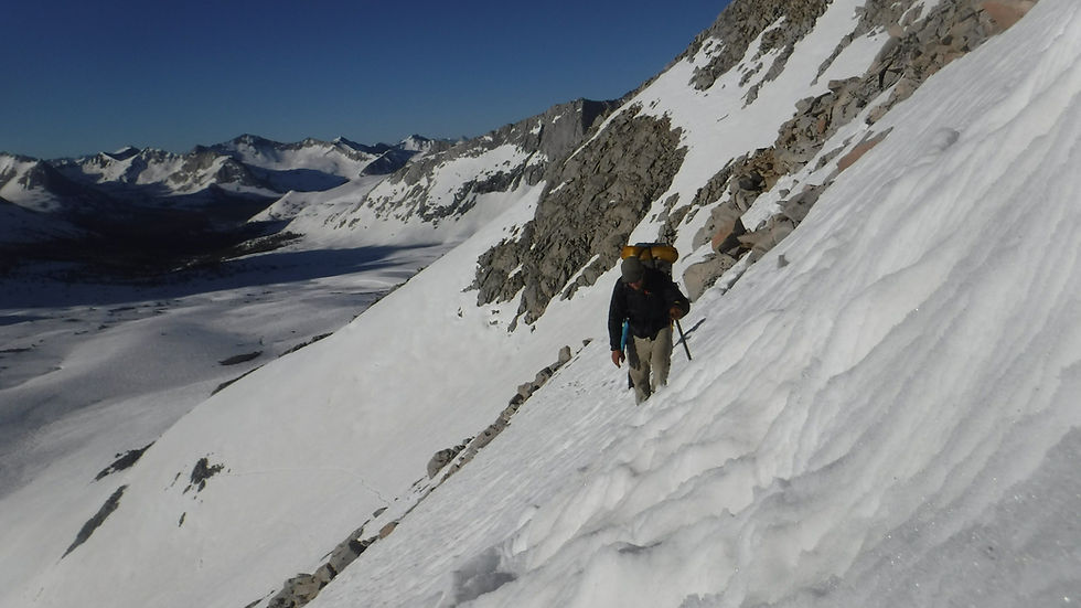
Along the way, we met some hikers who said a guy named Pickey had found my bag and would look me up in the next town if he didn't see me on trail first. It was a huge relief to know I wouldn't have to replace so many of my valuables. Near dusk, we came to a steep, long embankment. Presumably, the trail switchbacks gently down the slope, but we had only a slushy wall of snow. We slowly worked our way down, making our own switchbacks as we went. At the bottom, we came to our first ford, a swollen creek about thigh deep. We pushed our way across and staggered shivering into camp, where some other hikers had thankfully started a fire. We warned up, dried out as best we could and went to bed. We spent started early the next day, hoping to make quick miles to Forester Pass. It was not to be. We awoke to find frost on our tents and slush in our water bottles. Freezing, we followed an exposed trail out of camp. Half a mile later, we discovered this trail was not the PCT, which was, as always, covered in snow. After regaining the trail, we came to a second swollen creek. There was a snow bridge at the crossing that looked to be recently collapsed. We later learned that our Israeli friends had broken it on their way across. We walked upstream, finally finding a spot half a mile up where people were drying off on the opposite side. It looked like a tough ford, but they'd made it. We linked arms and fought the current, nearly losing our footing a few times but flopping on the far bank soaked and shivering. One of the people drying off asked if there was anyone by name. It was Pickey! He returned my bag, valuables intact. I gave him a Snickers, which is basically platinum in trail currency. The three of us dried off as best we could, and Matt and Mandy crawled into their sleeping bags to warm up. By the time we were ready to continue, we'd been hiking two hours and gone just more than half a mile down the trail. Approaching Forester Pass, we walked through a long snowfield, watching the mountain face we'd have to climb grow more and more ominous. The snow became slushier and we slogged on. We reached the base and saw tracks zigzagging up a steep snow wall. Slowly, we followed them.


Forester isn't as tall as Whitney, but it's the highest point on the PCT at 13,153 feet. Plus we were hiking it with full packs (we left most of our gear in camp when we climbed Whitney). We worked our way up the snow wall one slow step at a time. Near the top, we reached some rocky switchbacks, allowing us to climb nearly to the top. One obstacle remained: the ice chute. Spanning a short section of the trail was a near vertical white wall, plunging hundreds of feet down. We had to traverse it to get safely to the rock on the far side. Someone had kicked steps into the snow, and we followed them, ice axes held ready for the slightest slip. After getting across, we climbed a few more switchbacks and stood proudly atop Forester Pass. We'd knocked out an arduous and treacherous climb to reach the trail's highest point.


A few weeks earlier, in the desert, a hiker had come down to Hiker Heaven to report that Whitney would be impassable this year and Forester might be as well. After doing both in two days, we felt satisfied about disproving the fear-mongering. Soon, a fierce wind began blowing and we started to descend the other side, crossing from Sequoia into Kings Canyon National Park. We stayed along a ridge, and as we rounded the slope, the snowy expanse of the canyon laid out before us, mountains rising up on either side.


Forgoing the trail, we cut straight across the snow, glissading and slushing our way down. We routed via line of sight to landmarks along the route, eventually working our way to a campsite among some trees. The following day, it was time to go into town. But first we had to get over Kearsarge Pass. The trail in the Sierras doesn't intersect with roads, so you have to hike over long, steep side trails to get into towns to resupply.

After an extensive climb up steep slopes and boulders, we ascended the pass and began the longer, steeper climb down. At the trailhead, we got a ride down from a day hiker, and got a second hitch from the road into Bishop. In town, we had a happy reunion with Gravy and Mamie and went out for Mexican food to celebrate knocking out the first section of the Sierras. Day 52 was one I'd long awaited. My family had planned a vacation to coincide with my trip, and they drove down from Yosemite to meet in Bishop. We met with big hugs in a coffee shop, and soon they were meeting my hiking buddies over sandwiches and strawberry shortcake in a local park.
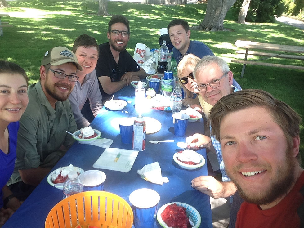
For me, it was special to see my family and my trail family get to know each other, as I'd been telling each about the other for a long time. I hung out with my family during the afternoon, catching up and telling them about the trail. For dinner, we all went out to a local burger joint and spent a fun evening together.
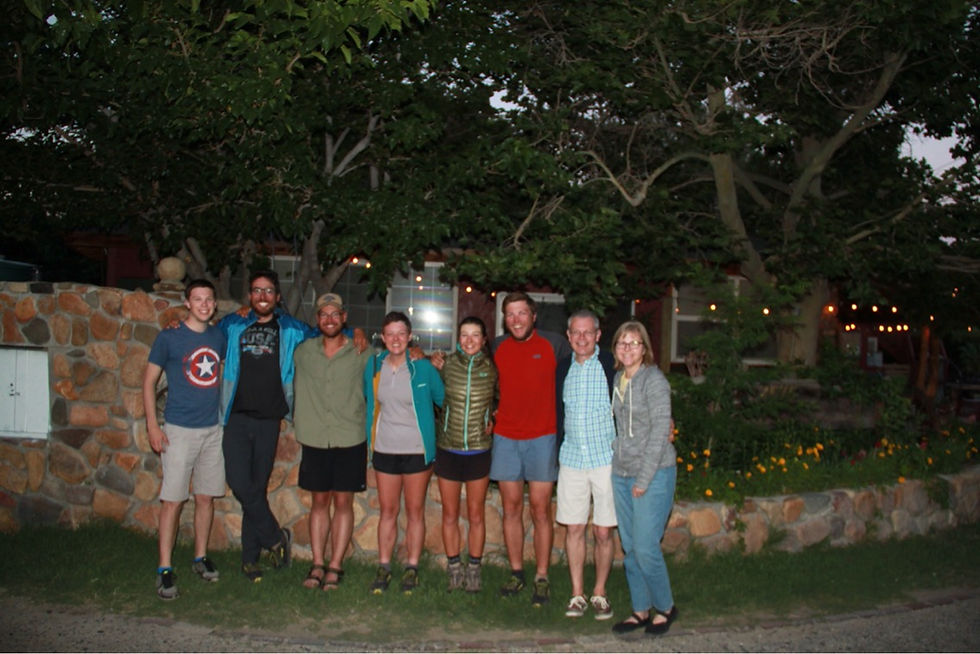
After breakfast the next day, my family got back on the road to Yosemite. Even though we'd only had one day together, it was rejuvenating to see them again—especially after hiking nearly 800 miles for a rendezvous. We started to hear reports of people dropping out, and others skipping ahead, with hopes to return to the Sierras after more of the snow has melted. Soon, it became apparent that close to three quarters of the thru-hikers who made it into Bishop would not be hiking back into the Sierras anytime soon. This included many hikers who had finished the Appalachian Trail. Some thought the snow was too physically demanding, while others were unnerved by scary reports of what was ahead. Mandy and Mamie decided they would be more comfortable hiking the Sierras later in the year, and decided to skip up to Northern California. Gravy, Matt and I decided to go forward, with extra precautions and backup plans. It wasn't a decision anyone took lightly, and we were morose as we realized it would split the group. We spent our last evening in a hotel, trading memories and laughs. The next morning, we said our goodbyes before Mandy and Mamie caught their bus north. Glumly, the rest of us prepared to head back into the mountains. After getting some gear and groceries, we got a ride back to the trailhead, where we spent the night. Day 55 started with the most strenuous hike yet. We were loaded down with 10 days of food—part of our extra precautions—and had to hike back up steep, snowy Kearsarge Pass. A few miles later, we had to tackle Glen Pass, with its sheer snow face and crest near 12,000 feet.


With our heaviest packs yet, we slowly started the climb, stopping often to catch our breath. By the time we hit Glen, we were starting to get used to the weight, if no less exhausted. From the the top, we enjoyed a long glissade down. We knocked out a few more miles before realizing we had nowhere to camp. Eventually, we found a tiny dry spot under a tree with just enough room for our tents.

The next morning, we came to a river with no obvious ford. A snow bridge had spanned it, but broken in the middle. The gap was small enough to jump, but we worried about slipping back down the snowbank on the other side. We solved it action-movie style. I grabbed my ice axe, got a running start and leaped across. The axe grabbed the snow, and I pulled myself up the rest of the way. After throwing the packs across, Matt and Gravy followed suit.

That afternoon, we hit our first dry trail in a while, enjoying a few easy miles below the snow line, along with some deer who were grazing near the trail.


Late in the day, we ascended, trying to get some of our climbing out of the way before tackling Pinchot Pass in the morning. As 12,000 foot passes go, Pinchot was relatively benign, strenuous but not treacherous. We summited early on Day 57, then came down and crossed a raging river on a log.


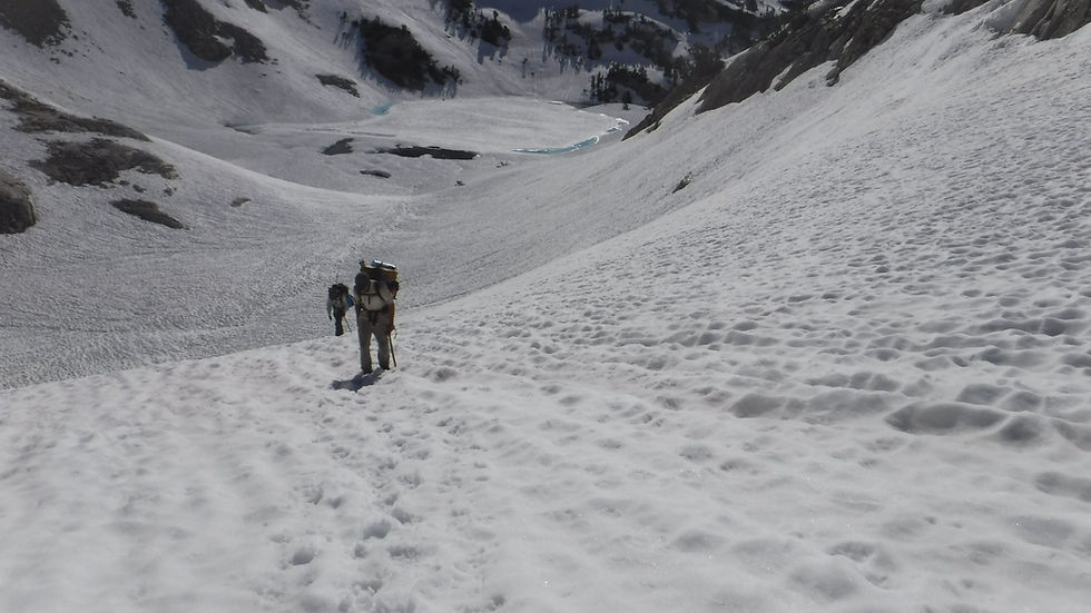
We spent the afternoon hiking through a snowfield, hoping to set up an early morning ascent of Mather Pass. Mather was rumored to be the steepest and scariest of all the passes, and we wanted to climb it just after dawn while the snow was still firm. As we got close, though, we realized there was nowhere to camp. For miles, we saw nothing but snow. Eventually, we settled on a boulder, an island of rock in the expanse of white. It was uneven and uncomfortable, but dry enough to work.

That evening, I got up to pee and walked into a scene I'll always remember. From my island perch, I was surrounded on all sides by snow, spreading for miles. Rising above it, studding the horizon in every direction, were granite peaks with their own blankets of powder. Above it all, lending a ghostly white illumination to my snow-sea beneath the mountaintops, were thousands of stars and the cloudy expanse of the Milky Way. I don't often stay up late enough to stargaze, but I'm glad my bladder gave me the opportunity that night. Mather proved to be as advertised: steep. We started up it with the first rays of dawn, hiking on snow that was still ice hard. We found faint tracks up the left side, not deep but firm enough to grip with our crampons. Step by step, we worked our way up, sometimes so vertical it felt like we were climbing a ladder. At the top, we hoisted ourselves over a cornice and breathed a little easier.


On the way down, I took a bad step on some ice and went sailing down a steep, still frozen, face. I'd self-arrested plenty of times, but always quick stops in slushy conditions. Now I was on my back and accelerating fast. I flipped over, lifted my feet and dug the ice axe in below my shoulder. Ice flew everywhere as I started skidding, and gradually I came to a stop. Other than some minor cuts on my hands, I was fine. More importantly, I'd proved to myself that the skills I'd worked on with the ice axe could pay off in a real situation. As we continued down from Mather, we started to ease below the snow, walking through a lush green valley. Water ran everywhere, snowmelt from peaks on both sides. As often as not, the trail itself provided a channel for the water, soaking our feet as we waded through.


Though the valley's snow had melted, the winter's avalanches had left huge swaths of trees downed across the trail, forcing us to bushwhack extensively at times. We climbed the other side of the valley, camping on the last dry spot we could find as we headed back into snow. We planned our earliest start yet for Muir Pass, knowing it was preceded and followed by miles of open snowfield. Up at 3 a.m. on Day 59, we hoped to crank out miles before the snow turned to slush. Our plans were foiled when, for the first time in our Sierra hike, overnight temperatures failed to dip below freezing. Up we climbed, each white hill leading to another, the snow getting softer and softer as the sun began to warm the day. Finally, we crested a ridge and saw the stony outline of Muir Hut marking the top of the pass. We took a long lunch at the shelter, enjoying the views from our perch.


We started slushing our way down, stopping at a pristine mountain stream that wound through snowbanks just below the pass. I drank a liter straight from the flowing water, my first unfiltered drink on the PCT.


As we continued down, we realized we'd followed footprints to the wrong side of the creek, forcing us to ford at a shallow point. A few miles later, we found a flat and dry campsite, a luxury after many days above 10,000 feet.

On Day 60, we linked up with some friends to cross Evolution Creek. We'd been running across this group—mostly internationals—quite often, and enjoyed spending time with them. They told us they'd found a waist-deep crossing for Evolution. Knowing that the "official" PCT crossing was chest deep, we followed their lead, wading the creek early and then bushwacking along the water for five miles until we came back to the trail.

From there, we descended quickly, dropping into dry terrain and green valleys. In the afternoon, we faced intermittent bouts of rain and mosquitoes, annoying but not quite the challenge of hiking over snow. We slept next to a raging river and heard fallen logs thunder by as they crashed into other timber. We left the PCT on Day 61. We knew that a creek not far ahead was somewhere between impassable and extremely dangerous, and most hikers planned to take an alternate trail around it. We stayed at lower elevations, walking through plenty of meltwater but no snow. After we reached the end of the alternate trail, we walked down a forest road to Mono Hot Springs, a small resort where we acquired some much-needed snacks and beer.

The next day, we got a hitch to Vermillion Valley Resort, a PCT-friendly establishment that welcomed us with free beer, a delicious breakfast and a well-stocked store to resupply on food. In the afternoon, we followed a trail from the resort back toward the PCT, crossing some creeks on logs and camping on a boulder field above the snow. We started climbing early on Day 63, a steep ascent to Goodale Pass, our last obstacle before rejoining the PCT. After we scaled the pass, we headed down and quickly rejoined the trail—well, footprints in the general direction of the trail.


As we hiked a ridge near a frozen mountain lake, a bald eagle flew close below us, no doubt annoyed the ice was blocking his access to the fishing grounds. Soon after, we came to a small channel we had to cross. There was little current, but the frozen surface had separated into icebergs. They were dense and close together, and we saw footprints across, so we hopped from iceberg to iceberg until we reached the far bank.

On Day 64, we hiked a few miles of PCT, then veered off a snowy side trail until we came to a road. After catching a ride into Mammoth Lakes, we ate our fill of pizza, Chinese food and beer before heading to a trail angel's house to spend the night. We'll take a hard-earned zero day here before heading back to the Sierra. After 10 days in the most isolated backcountry we've ever seen, we're exhausted, but we feel a huge sense of accomplishment—especially knowing so few hikers attempted the section we just finished. We still have many more miles of the Sierra and its challenges, but we'll use the skills and stubbornness that got us this far to get through those as well. But not today. Today we're going to play some mini golf.
Comments